| North in the Spring #26 -Columbia Icefield
by John Neville  There is always a certain amount of excitement when we visit the Rockies. This September we travelled up the Athabaska River valley from the Alberta side. The river was low and very brown carrying away glacial mud and fine silt. The word "Athabaska" comes from the Cree language and means "place where the reeds grow" and refers to the area in Lake Athabaska in northeast Alberta. The Aspen leaves were bright yellow and some golden brown before falling. The deciduous leaves were in marked contrast to the dark green Lodgepole pines. As we approached closer to Jasper cars were pulled off to view and photograph the herds of elk. The cows and bulls were in separate groups. The bulls with full racks of antlers, and all appearing quite docile? Park staff were trying to keep tourists away from the bulls as this is the rutting season and the bulls are in an agitated state. They will be fighting tonight, with head butting charges and loud bellowing, so that the strongest may mate with the cows.
Also in the area Rocky Mountain Sheep were crossing the road to reach salt licks to obtain minerals needed in their diet. Sometimes we have also encountered Mountain Goats using the salt licks. That day we quickly turned south on Highway 93, the Columbia Icefields Parkway! It was opened in 1942, after being used as a "make work project" through the dirty thirties. A beautiful avenue has been created between the Central Range, where most of the icefields are and the Frontal Range, to the east. We passed the Whistlers and Wapiti campgrounds, the Five Lakes hiking trail and more of the Athabasca River. The last two features reminded us of recording birds and river rafting.  We did stop briefly at a noticeboard describing David Thompson's journey up the Athabasca and Whirlpool Rivers, over a ridge and descending into the Columbia River system in 1811. Thompson went on to make the first complete traverse of the Columbia river! In 1827, George Simpson, the HBC Governor named the route for his bosses in London, the Committee Punchbowl. As the road began to climb steadily through the Subalpine Zone the Stutfield Glacier became briefly visible on the skyline. Just to our right the Sunwapta river flowed on the level parts with braiding and then loud and wild through the canyon with lots of waterfalls feeding into it. We then stopped at the Columbia Icefield Visitor Center, opposite the Athabaska Glacier, to seek information and check our tickets for the following day. We did stop briefly at a noticeboard describing David Thompson's journey up the Athabasca and Whirlpool Rivers, over a ridge and descending into the Columbia River system in 1811. Thompson went on to make the first complete traverse of the Columbia river! In 1827, George Simpson, the HBC Governor named the route for his bosses in London, the Committee Punchbowl. As the road began to climb steadily through the Subalpine Zone the Stutfield Glacier became briefly visible on the skyline. Just to our right the Sunwapta river flowed on the level parts with braiding and then loud and wild through the canyon with lots of waterfalls feeding into it. We then stopped at the Columbia Icefield Visitor Center, opposite the Athabaska Glacier, to seek information and check our tickets for the following day.
Because the Columbia Icefield is a high altitude basin in which snowfall collects and from which a number of glaciers flow, it is considered a single geological feature. The Columbia Icefield is considered the largest of the numerous icefields that straddle the Central Range or the continental divide in North America. It is approximately 165 km2, similar in size to metro Vancouver. However, this is a misconception, as the Andrei Icefield, north of Stewart BC is larger, as is the Seward-Bering icefield system in coastal Alaska. Everything starts at the apex, which in the Canadian Rockies means Mount Snow Dome in the Columbia Icefield. The downward pressure of snow eventually turns the snow crystals into ice. The increasing depth of ice turns plastic and starts to move laterally, creating glaciers. The icefield varies from 150 to 600 m. in depth. The Snow Dome is a triple continental divide at 3510 m. elevation. Snow falling on the Dome may be directed to one of three different oceans. Several glaciers flow westward from the Dome into BC's Hamber Provincial Park (a very special park) and feed the Bush and Wood Rivers that flow into Kinbasket Lake and then flow to the Pacific via the Columbia River. The Athabaska River is fed directly by the Columbia Glacier on the eastern side and eventually reaches the Arctic Ocean via the Mckenzie River System. The Athabaska Glacier feeds the Sunwapta River which is a tributary of the Athabaska River. --Confusing eh!--- The huge Saskatchewan Glacier feeds the North Saskatchewan River which flows east to Hudson Bay and the Atlantic Ocean. Only the Athabaska Glacier is easily accessible by road. 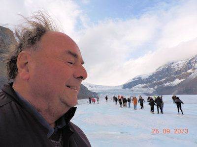 The Stoney People used this area as an important meeting place "chaha tonga" the big ice meeting place. The park is within the treaty boundaries of Treaty 6 and 8. The dark side of this story is that when Jasper National Park was created in 1907, all First Nations People were evicted from the park. On October 19, 2023 it was announced that the National Park would allow a short hunting season for the Stoney People for the first time since their eviction.
I was startled by a loud, roaring, blustery sound about 3 am. We were camped across the valley from the Athabaska Glacier. The air passing over icefields and glaciers is cooled quickly at night and with the aid of gravity roars downhill. This is known as the "Katabatic Effect" and certainly woke me up! A few hours later we were climbing onto a bus with large tractor tires and other passengers from around the world. The bus was soon ascending a hill and then plunging down a 32* slope of the lateral moraine onto the Athabaska Glacier. The cheerful driver told us that 32* was the steepest road in the world. Moraine is an old french word meaning rocks deposited by ice. We passed NASA scientists doing research before reaching an area marked off by red cones. 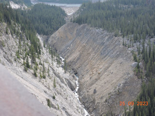 We were given a safety talk, meaning that we should stay within the cones, as there were crevasses beyond those markers. The snow had all melted away by September and the surface was quite rugged with loose pieces of ice. It was slippery on sloping areas and easiest to side-step (as with skies) to stay upright. There were about 60 m. of ice below our feet! The temperature was cool and I felt as though I had landed in the Ice Age and could have been in Greenland or the Antarctic! There have been five Ice Ages, as far as we know. Before leaving I tried drinking a little ice water and it did taste quite pure almost like distilled water. We were given a safety talk, meaning that we should stay within the cones, as there were crevasses beyond those markers. The snow had all melted away by September and the surface was quite rugged with loose pieces of ice. It was slippery on sloping areas and easiest to side-step (as with skies) to stay upright. There were about 60 m. of ice below our feet! The temperature was cool and I felt as though I had landed in the Ice Age and could have been in Greenland or the Antarctic! There have been five Ice Ages, as far as we know. Before leaving I tried drinking a little ice water and it did taste quite pure almost like distilled water.
We were subject to one more thrilling experience on this bus-ride adventure: the Skywalk. We were taken to the edge of the Sunwapta Canyon. A good paved trail took us to a glass-bottomed walkway or u-shaped bridge returning to the same cliff edge. There was only fresh air for 280 m. down to the raging Sunwapta River. Many people became dizzy and were calmed by a tour guide. I was very conscious of the slight shuddering of the glass in time to my foot steps. It was a relief to step back onto terra firma. 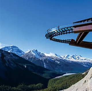 Before leaving the area Heather took some pictures of the glacier across the valley from the campsite. Nearby were small clumps of Engleman Spruce which began growing when the glacier started to retreat in 1844. We also noted one Canada Jay and three pairs of Raven. Several years ago, driving the Parkway, we were stopped by dense clouds reducing visibility to zero. We pulled off at the Athabaska parking lot and found a Raven grounded, waiting for the mist to clear, like us. The car park is at the bottom of the glacier's track. A fifteen minute walk takes you up through the rubble to the snout of the glacier and the creek emerging from the ice. Markers indicate where the snout reached in past years. At the present variable rate of retreat it will take between 30 and 60 years to completely disappear.
If you wish to know more about our shrinking icefields and glaciers check out Our Vanishing Glaciers: The Snows of Yesteryear and the Future Climate of the Mountain West by Robert William Sandford Victoria: Rocky Mountain Books 2017. 9781771602020 |