| North in the Spring #25 - Columbia River
by John Neville 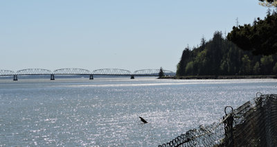 We reached the mouth of the Columbia (Wimahl in the Chinookan language meaning Great River) by travelling south on Hwy 101 on the west side of the Olympic Peninsula. A ramp takes you up onto a skinny metal bridge, which could have been made with a giant Meccanoo set. The bridge follows the line of the "the Bar". Some of the early sailors like Captain Vancouver missed the river on his first pass because it was hidden by multiple sandbars. Some of it has now been dredged away for ocean going freighters. "The Bar" was also the site of many shipwrecks for Euro-Americans involved in exploration and the fur trade. Captain Robert Gray first crossed the great sand and gravel bar in May 1792 and explored the first 32 km. of the river. "During our short stay we collected 150 otter and 300 beaver." He named the waterway after his ship Columbia Rediviva. His name lives on in Gray's Bay and Gray's Harbour. David Thompson was the first explorer to record his transit along the full length of the river in 1811. This led eventually to the Hudson's Bay headquarters at Fort Vancouver opposite to Portland Oregon. The river carries more water into the Pacific than any other river in North or South America. It starts its journey at 838 m elevation in the Rocky Mountain Trench of the East Kootenays at Columbia Lake. Its total length is about 2000 km. This waterway drains the Kicking Horse, Blaeberry, Canoe, Elk, Goat, Lardo, Duncan, Slocan, Kootenay, Pend-d'Oreille, Kettle, Okanagan, Similkameen and other rivers in BC. However, the biggest tributary is the Snake River, wholly within the USA. Over millenia glacial till, sand, gravel, organic matter, mud and pollutants have been washed downstream to form "The Bar" which extends north and south beyond the river's mouth.
In 1933 the federal government in Washington DC used its financial might to construct the Grand Coulee and Bonneville dams. In 1942 both huge projects were completed, just in time to produce electrical power for the war machine in Portland and Seattle. The cheap power also allowed water to be pumped for irrigation. One major problem had not been solved; the periodic flooding in the upper and lower Columbia Valley. The last devastation was in 1948. Not surprisingly, flooding and maximizing power production were the major issues to be solved by the Columbia River Treaty. Two friendly nations, Canada and the USA, signed the Columbia River Treaty in 1964. This included the building of storage dams in Canada and more electrical production in the USA. The storage dams hold back a maximum of 15 million acre feet of water and have been paid for through the Treaty. BC has shared in the additional profits created by the agreement. There were two major problems for First Nations and the people living around the Kootenays:
I was a Director of the Regional District of Central Kootenay 30 odd years ago when we asked our provincial government to consider creating a permanent fund from the Treaty income for restoration in the Kootenays. It was wonderful when in 1995 the Columbia Basin Trust was created and now generates $50 million per annum for restoration projects in the Kootenays! I was also the Chairman of the electrical department for the city of Nelson for seven years and learned much about the distribution of power from BC Hydro and the Bonneville Power Authority. I whimsically titled myself "The Electric Chair".  The Columbia River Treaty is up for renewal in 2024 and no doubt very serious negotiations are underway already. There are many serious issues for the negotiators to consider, not least the increasing demand for electrical power. How much extra money will BC receive now that the storage dams have been paid for? What to do, as water temperatures increase in the lower river and glaciers continue to melt? How to breach the Grand Coulee and other upstream dams to allow salmon to once more reach the upper Columbia and its tributaries? Many insects, fish, mammals and plants would benefit from the re-introduction of the salmon! Should the new agreement be more flexible to address the fast changing environmental needs?
The one part of the river which has not changed much reaches from Columbia Lake to the Moberly Marsh near Golden a distance of about 180 km. These wetlands have been too difficult to exploit for human needs. Birds, Insects, Bull Snakes, Beaver, Deer, both kinds of Bear, Cougar, and occasionally Wolves use this part of the Rocky Mountain Trench. Its an important flyway for Tundra Swans, geese, Coots and many more. Robin Cody, when he canoed the marsh at Columbia Lake outflow was intrigued by a Coyote swimming past him with a Mallard in his mouth. He described the sombrero-shaped nest of the Osprey and the shy movements of the large Moose (see Voyage of a Summer Sun: Canoeing the Columbia River book by Robin Cody, 1995). I recall sitting on a small cliff above the river with Bank Swallows flying in and out of their burrows below my feet. On the same visit, I positioned myself in the middle of a Columbia Ground Squirrel colony and enjoyed recording the little critters. The Upper Columbia River Valley is a very important, much of it unprotected area, that really needs more protection. This could be a very special project for BC Nature to initiate the creation of a KBA, Key Biodiversity Area, a site that contributes significantly to the global persistence of biodiversity. Standing on the river bank at Dismal Nitch, on a sunny May morning 2023, it was hard to imagine part of the Lewis and Clarke Expedition landing here on a stormy November day in 1805. A gale was raging: 3 m high waves, wind and rain were battering the shore and many 60 m tree trunks were crashing together along the river bank. Fortunately, for the starving Corps of Discovery, the Chinookan People came to their aide with food. As we stood admiring the huge river estuary, a Double-crested Cormorant popped up near the bank, gave one guttural call and dove again. In a nearby park, called Camp Station, there is a wonderful tribute to the Chinookan people: with explanatory panels and beautifully crafted canoes illustrating their marine skills. The ocean going example was 23 m long, carried 20 people and several tons of cargo. Smaller examples were also displayed for river and tributary travel. From 1801-1853 the Chinookan people were decimated by Smallpox and Malaria epidemics.  It is highly appropriate that the magnificent Chinook Salmon is named after these people. First nations have fished the river for millennia (see Paul Kane's painting 1847 at Kettle Falls, upstream from Grand Coulee). Recently, the Okanagan and Colville First Nations recorded a record number of Sockeye Salmon, 600,000, returning to the Okanagan River below the Grand Coulee Dam. This is a great achievement on their part! It is highly appropriate that the magnificent Chinook Salmon is named after these people. First nations have fished the river for millennia (see Paul Kane's painting 1847 at Kettle Falls, upstream from Grand Coulee). Recently, the Okanagan and Colville First Nations recorded a record number of Sockeye Salmon, 600,000, returning to the Okanagan River below the Grand Coulee Dam. This is a great achievement on their part!
BC Nature should be appealing to the provincial government to negotiate in the Columbia River Treaty Agreement 2024 to breach the Grand Coulee and upstream dams to allow the return of Salmon and more flexibility in the new treaty to respond to the changing environmental needs of the river system. In addition, the upper Columbia River Valley in the Rocky Mountain Trench needs more protection. |