North in the Spring #14
Kamloops to Alaska Highway the Eastern Route Part One: Kamloops to the Canoe River by John Neville
This is an alternate northeasterly route from Kamloops to the Alaska Hwy. following Highway 5 up the North Thompson River Valley to Valemount. We soon pass through the small community of Barrier and the remnants of a 2003 forest fire. There is a lesson to be learnt here as the fire is believed to have been started by a cigarette. Nature is now rebounding: bunchgrass, several shrubs and Aspen are re-sprouting from their burned bases. Conifers will take longer to appear, as they rely on dispersed seeds from unburned areas.
In the late summer and early fall many of the riverside trees are occupied by Bald Eagles feasting on the spawning salmon. We have often counted five or six in one tree. The valley separates two mountain chains. First, to the east, the Monashees and to the west the Caribou range. Lets go back in time, 60 to 100 million years ago, when the Percell, Selkirk, Monashee and Caribou ranges were all contiguous parts of the Rocky Mountain chain. As tension in the earth's crust diminished valleys appeared between the separated mountain ranges. 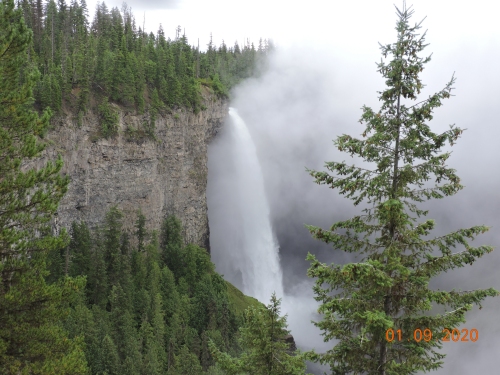 Our first stop was at Clearwater for groceries and some treats from the bakery. Then, we ascended the Clearwater Valley towards Wells Gray Provincial Park. We were pleased to see the new university building for students to do research in the region. About five years ago we witnessed the sod turning ceremony. Robert Bateman did the honors and had to search for a soft spot in the glacial gravel that would allow penetration of his spade.
200,000 years ago many layers of lava were laid down in this region. The rivers plunging over the edge of these flows create many natural wonders. The most spectacular and popular sight is Helmecken Falls, named after one of BC's early pioneers. It is more than twice as high as Niagara Falls. where the Murtle River cascades over the 141 m. wall of the canyon. This is only one of 39 named falls in Wells Gray Provincial Park and emphasizes the varied geology of the area. A solitary MacGilvray's warbler shared the spectacle, the roar, the mist and foaming water when we approached the falls. Below the safety fence there were five pairs of sunglasses scattered down the cliff. Presumably, their owners lost them when they leant over too far! We had to wait about half an hour for the mist to clear enough for a photo. It is well worth climbing a steep 3.6 km trail to a viewing tower on Green Mountain. The turn off is at 36.2 km along the Clearwater Valley Road. This lookout allows the viewer to see many flat-topped volcanic cones (aka Tuya) that were formed under the glaciers during the ice age. Hiking and canoeing are two of the best ways of exploring the lakes, rivers and the Caribou mountains of this wondrous park.  The park is 525,000 hectares and has recently been connected with the Bowron Lakes Park, by the creation of Caribou Mountain Park. This is an excellent addition to the provincial parks system as it allows for the free roaming of animals that need large territories, such as: Grizzly, Moose, Wolverine, Wolf and Caribou. Black Bear are very common, and easy to see in Wells Gray. One morning we stopped next to an old bear ripping up small green shrubs and chowing down. He did not appear to notice the mosquitoes around his eyes, or the motor home 3 m. away. He was free, safe and seemed to know it. On another occasion we witnessed a younger Black Bear swimming the river and starting to graze while still dripping wet.
At Messiter Summit, 765 m. elevation on Hwy 5, we became aware of another recovering forest. In August 1998, more than 100 lightning strikes set off a similar number of forest fires. The Elevator Fire swept over this summit. Twenty odd years later, nature with some help from tree planters, have regenerated a healthy young forest with Aspen, birch, Douglas Fir, spruce, pine and Western Red Cedar. Just before Valemont, we crossed the Canoe River and turned east onto Cedarside Road. The road followed the Canoe River Valley towards Kinbasket Reservoir (aka the Big Bend of the Columbia River). The Columbia River flows north from Golden, west around the edge of the Selkirks, then south to Revelstoke. The Mica Dam was built as part of the Columbia River Treaty in 1964 and created the resevoir. In 1811 David Thompson camped at the mouth of the Canoe River while exploring this region. The views from this valley of the Monashee and Selkirk ranges are very dramatic. Canoe Mountain, immediately to the south represents the northern limit of the Monashees and is pock marked and scarred by glacial activity over millennia. Directly east across the resevoir is the northern limit of the Selkirk range. To the northeast are the white helmeted peaks of the Rockies. This grand landscape made me feel so insignificant. |