On this trip we are going to travel north on Highway 5A and reconnect with Highway 97. First, we visited the Swan Lake Wildlife Viewing and Habitat Restoration Project located 2 km north of Princeton, on the Princeton-Summerland Rd. Mary Masiel of the Vermillion Forks Field Naturalists, kindly acted as our guide. A blue and white nature sign on the left indicates the entrance. The lake is located in a kettle or deep depression, caused by glaciation about 12,000 years ago. The rolling grasslands are dotted with huge Ponderosa Pines. The 57 hectares have an abundance of native plants and some introduced species, such as Knapweed. The 5 km of trails allow visitors a wide variety of viewing opportunities without stepping on fragile grassland.
Mary explained that Vermillion Forks, the name of their club, used to be the name of Princeton. The club with some financial support from BC Nature has built two blinds, a toilet, picnic benches and many interpretive signs. We stopped to view Pine Grass, Pasture Sage and Giant Wild Rye, all clearly marked with hand-painted signs. It was a very hot afternoon but we were serenaded by the languid whistles of a Black-headed Grosbeak. I take my hat off to the club and the special efforts of Madelon Schouten for preserving a very attractive natural site for us all. Highway 5A took us north through ranch country, ripairian wetlands, cliffs and beside Tulameen Lake. We then crossed into the Thompson Nicola watershed. We turned west onto Coalmont Rd, and right onto a gravel road to spend the night at Davis Lake. This turned out to be a very popular Recreation Area, with more than a few ATVs. We were pleased to see notices about unlicenced ATV’s but not many were in compliance. At 4 AM all was quiet and I went to the edge of a vibrant wetland with my recorder. Three Marsh Wrens were singing vigorously amongst the Bullrushes. If one switched song, the others usually followed. I enjoyed recording them for an hour. The western race of Marsh Wren have many variations on their song, much more than the eastern race. Approaching Princeton from the east, we were impressed with a sign cautioning that we were entering a Badger Crossing Zone. Wherever there is sandy soil in the interior grassland valleys Badgers can dig burrows. These holes were often later used by Burrowing owls. This largest animal in the Weasel family tends to live a solitary life, except when there are kits. There are estimated to be as few as 350 in all of BC. They travel a great deal and are very vulnerable to traffic. Hunting and trapping Badger was stopped in 1967. Their favored prey are Columbia Ground Squirrels and Yellow-bellied Marmots. In the Caribou they also eat Muskrats. American Badgers live in the wild about four years. They enter a state of torpor, for about 6 weeks during the winter, when metabolism slows down. In comparison, the European Badger has a complex social structure and live in badger sets, or mounds. The American Badger is at the base of the weasel family, which includes Fisher, Wolverine, River Otter, Mink and Short-tailed Weasel. A little further up 5A we turned right towards Kentucky-Alleyne Provincial Park. As we crossed a cattle guard two Marmot leapt out. We found a quiet campsite above another kettle lake, called West Pond. A Columbia Ground Squirrel kept popping up next to the picnic table obviously expecting a hand out. At dawn the predominant birds on West pond were male Barrow's Goldeneye. I recorded 4 of them that seemed to be displaying, although there were no females nearby. This park is seriously concerned with the protection of Western Toads. 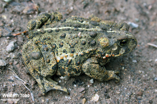 There is an underpass below the camp road to allow the safe passage of toadlets. In a recent film called “Toad People”, citizens near Nakusp have worked with highways to install culverts under Highway 6. This has allowed thousands of Western Toads to move from Summit Lake back into the saftey of the forest. The Nicola Naturalists and others built the underpass from West Pond. Together with a low drift fence, the underpass funnels the migrating toadlets into the forest. Breeding females grow to about 12.5 cm and males between 6 and 11 cm long. A female lays from 5 to 15,000 eggs each year, and they are surrounded by a layer of jelly. The arched culvert below the road is proving successful in protecting the toadlets. However, human activities in many other places are severely reducing Western Toad numbers. There is an underpass below the camp road to allow the safe passage of toadlets. In a recent film called “Toad People”, citizens near Nakusp have worked with highways to install culverts under Highway 6. This has allowed thousands of Western Toads to move from Summit Lake back into the saftey of the forest. The Nicola Naturalists and others built the underpass from West Pond. Together with a low drift fence, the underpass funnels the migrating toadlets into the forest. Breeding females grow to about 12.5 cm and males between 6 and 11 cm long. A female lays from 5 to 15,000 eggs each year, and they are surrounded by a layer of jelly. The arched culvert below the road is proving successful in protecting the toadlets. However, human activities in many other places are severely reducing Western Toad numbers.
Toads spend most of their life in forests, feeding on insects and worms. The toads in turn are eaten by Coyotes, Ravens and snakes. Toads hibernate for up to 6 months per year. In early May, the adult toads mate at communal breeding sites. Life expectancy for a toad is 9 to 11 years, but some have survived for 20 years. In June, tadpoles can be seen feeding on algae in West Pond. At this stage, they are readily eaten by snakes, birds and Dragonfly larvae. In July, long black lines of tadpoles can be seen, swimming and feeding along the shoreline. In late July and early August tadpoles magically transform into miniature toads. This is an instant example of the evolution of ocean bound critters moving onto the land. Leaving the park after a very restful 24 hours we again headed north. 5A converges with 97C passing Corbett Lake on the right. Kane Valley Road appeared on the left. The Kane Lakes also have breeding Western Toads. A little further along on the right, Lundbom Rd appeared which leads to some good birding and wildlife viewing areas. There is also a memorial to Laurie Guichon on the right. It is situated by open grasslands, as his work included conservation and the development of ecologically sustainable ranching. At the top of the hill a view of the snow-capped Cascades appear to the west. After reaching Merritt we went to visit our friends, President Alan Burger and his wife Andrea. We were very interested to hear they had found a Badger burrow on their land, this last winter. Alan has seen and photographed a Badger on the nearby Douglas ranch. Early in the evening Andrea and Heather checked out the Kane Lakes and found black streaks in one wetland, caused by thousands of little fingernail sized tadpoles. 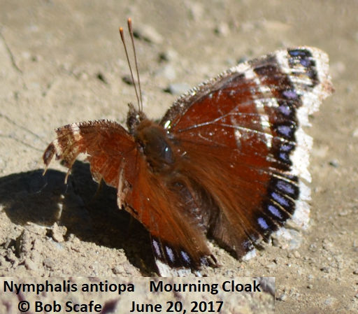 Bob Scafe is another Nicola Naturalist and photographer. He introduced us to the Mourning Cloak. This butterfly looks dull and drab on the outside, like mourning garments. It is only when it opens it’s wings that it reveals the soft maroon with blue spots and yellow fringe of it’s inner wings. Truly, a most beautiful butterfly. An interesting feature makes the Mourning Cloak unique in the Nicola Valley. It is our only B.C. butterfly that “Winters Over” as an adult. It finds a loose flap of bark on a tree, or perhaps a woodpile, to provide shelter from the winter elements. By the end of October it is usually tucked away, and won’t emerge until early March. At this point it will seek a mate, in order to perpetuate the species. Mating done, the female will then lay her eggs on an alder or poplar tree, and in time the larvae will hatch and begin eating the leaves. A few more weeks and there will be a number of fresh Mourning Cloak butterflies emerging from their pupas. The butterfly in this picture has survived the winter, and has mated. She will now lay her eggs, and in a very short while, she will die, and the cycle is completed. Bob Scafe is another Nicola Naturalist and photographer. He introduced us to the Mourning Cloak. This butterfly looks dull and drab on the outside, like mourning garments. It is only when it opens it’s wings that it reveals the soft maroon with blue spots and yellow fringe of it’s inner wings. Truly, a most beautiful butterfly. An interesting feature makes the Mourning Cloak unique in the Nicola Valley. It is our only B.C. butterfly that “Winters Over” as an adult. It finds a loose flap of bark on a tree, or perhaps a woodpile, to provide shelter from the winter elements. By the end of October it is usually tucked away, and won’t emerge until early March. At this point it will seek a mate, in order to perpetuate the species. Mating done, the female will then lay her eggs on an alder or poplar tree, and in time the larvae will hatch and begin eating the leaves. A few more weeks and there will be a number of fresh Mourning Cloak butterflies emerging from their pupas. The butterfly in this picture has survived the winter, and has mated. She will now lay her eggs, and in a very short while, she will die, and the cycle is completed.
There are many good birding places around Merritt. “BIRDFINDING in British Colunbia” by Russell and Richard Cannnings recommends: Lundbom Rd, Lindley Creek Rd and Nicola Lake. We stopped for lunch just north of these sites at the historic Quilchena Hotel established in 1908. On the right, soon after the hotel we came to Pennask Road leading onto the Douglas Ranch, where we saw and heard the Great Basin Spade-foot. 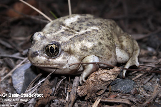 They like shallow wetlands and soft ground to bury themselves. In spring, the Spade-foot emerge from their winter habitat to gather at shallow ponds. In April, heavy raindrops wake these little critters. In the early summer, eggs hatch into tadpoles and after about 6 weeks they are transformed into Spade-foots. Emerging from their shallow burrows at night they eat grasshoppers, beatles and crickets. By October they are ready to hybernate. The finger-nail like spade on each hind foot allows them to dig backwards down 1.5 m into soft soil for the winter. They like shallow wetlands and soft ground to bury themselves. In spring, the Spade-foot emerge from their winter habitat to gather at shallow ponds. In April, heavy raindrops wake these little critters. In the early summer, eggs hatch into tadpoles and after about 6 weeks they are transformed into Spade-foots. Emerging from their shallow burrows at night they eat grasshoppers, beatles and crickets. By October they are ready to hybernate. The finger-nail like spade on each hind foot allows them to dig backwards down 1.5 m into soft soil for the winter.
On the left of highway 5A, we passed Nicola Lake (close to bursting its banks) and the Guichon Ranch( all 65,000 acres) . We next stopped at an attractive wetland supported by Ducks Unlimited and the Kamloops Naturalists. This site allowed me to record the bizzare sounds of the Yellow-headed Blackbirds. At Stump Lake we encountered 18 Red-necked Grebe. Several had already claimed floating debris for nest sites. Sworms of insects were hatching in the sun and swallows were gorging on them. A Barn Swallow quickly came to check out the motorhome for real estate. In the past we have had up to 3 in the vehicle when a window was left open. A Western Meadowlark sang his rich song right outside the door. Stump is quite a large waterway and like many other places this spring was flooded. Fences and docks were under water, side roads disappeared into the lake, and at the north end 5A was reduced to a single lane. There were more interconnecting lakes, wetlands, ranches and increasing numbers of cottages. Just after the turn-off for Roche Lake Provincial Park, we noticed at least 11 Bald Eagles feeding on a deer carcass. 5A ended at Highway 97. Thank you for sharing our journey in the BC Nature, we hope to meet you again soon, travelling North In the Spring. |