by John Neville
10 km north of Clinton we started exploring the Cariboo by turning west, off highway 97,the old Cariboo Wagon Road. A good gravel road took us through second growth evergreen forest, open grassland and some prosperous looking ranches. A sign noted that we were traveling through Stswecem'c (Canoe Creek), and Xgat'tem (Dog Creek) First Nations territory. We stopped at the Big Bar Provincial Park. The park is 332 h. on the edge of Big Bar Lake. At this quiet park we enjoyed the songs of some favourite interior birds, including: Ruby-crowned Kinglet, Western Tanager, Yellow-rumped Warbler, Downy Woodpecker, Dusky Flycatcher, Mountain Chickadee and Red-breasted Sapsucker. The road completes a 120 km loop back to Clinton. It passes through Marble Range Provincial Park, where you might see deer and California Big Horn Sheep. Murphy Shewchuk, in Cariboo Trips and Trails, gives detailed descriptions of this area, as well as many details of the early life of Interior Salish First Nation People.
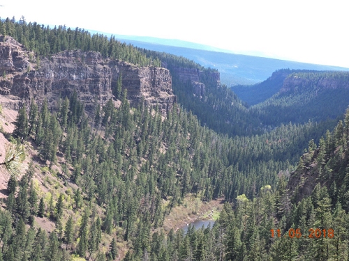
6 km further north on 97, we turned right towards Chasm Provincial Park. A well fed black bear demonstrated his traffic smarts running fast across the road and then stopping to watch us go by. The Chasm is 8 km long and protected by a 3067 h. provincial park. It's 600 m. wide, 300 m. deep and consists of numerous layers of red, brown, yellow and purple lava flows. This geological wonder was created by a glacial fed outflow about 10,000 years ago. The Chasm allows us to imagine the forces and structures below us as we travel on the Cariboo plateau. After another 1.5 km north along 97 we passed the left turn to Canoe Creek, Dog Creek and Alkali Lake. The Meadow Lake Rd. is an alternate route to Williams Lake. It gives access to a Fraser river crossing and the Churn Creek protected grasslands. A recent report had about 100 White Pelicans staging at Alkali Lake, waiting for the ice to melt on the breeding grounds in the Chilcoot. On a previous trip along that road I recorded Red-tailed Hawk, Northern Goshawk, Vesper's Sparrow and Lesser Scaup. We next turned right at 70 Mile House. The Green Lake loop follows highway 2, 24 and back onto 97. This route has paved roads and passes a variety of wetlands, lakes, provincial parks, resorts and private cottages. There is also access to four wheel drive trails into the back country. Our first side trip was to the quiet Sunset View campground. Our joy at dawn was to hear the calling Red-necked Grebe, Long-tailed Duck and Sandhill Cranes . Continuing around the loop, we often stopped to check out Marsh Wren, Ruddy Duck, Yellow-headed Blackbird, Great Blue Heron and the ubiquitous Ruby-crowned Kinglet. Our next stop was in the beautiful Aspen parkland at Emerald Bay campground. On our first night a Hermit Thrush came and sang above our campsite. We joked that he had come to serenade us, but in reality, we were in the middle of his territory. The park has well spaced campsites and a great location on Green Lake. I was amazed to find 4 individual House Wren singing their complex songs and counter singing near the lake. The loons and cranes were also very special at dawn. At Green Lake we had reached what is known as the Cariboo Uplands. This strip of land is to the east of Hwy 97 and stretches north from Green Lake to Prince George. The land is between 1200 and 1700 m. above sea level. This plateau was created with the Cariboo mountains, between 60 and 100 million years ago. At Chasm Provincial Park we had glimpsed that geology. After the last ice age thousands of lakes and ponds were left on the plateau. In addition to Aspen, Pine and Spruce trees, this area has Douglas Fir on south facing slopes, Cedar and Hemlock in valley bottoms. Please join us for Part 2 of the Cariboo in the winter edition of this magazine, when we will cross the Cariboo Mountains to visit Mahood Lake. Reference: Cariboo Trips and Trails by Murphy Shewchuk ISBN 978-1-55455-031-9 Continue to The Caribou Part 2 |