North in the Spring #12
Burns Lake and the Lakes District by John Neville
We turned off Hwy16, left or south, at the community of Burns Lake. Hwy 35 led us over Burns Lake on a long bridge and then past more lakes, farms and prosperous looking ranches. A newly born calf was just taking its first steps as we passed one of the ranches. The Francois Forester ferry took us for a 15 minute free ride across Francois Lake, just one more pristine waterway. Francois Lake boasts trophy sized Rainbow trout and all the other lakes seem to claim more modest 5kg fish! The Coastal Mountains were close by on our west side with their ancient rounded tops. The whole chain was still blanketed with snow in mid May. We stopped at a small marsh. Red-winged Blackbirds, Snipe and Canada Geese dominated the soundscape. After dark everything changed: three Sora, five or more croaking Wood Frogs and a small flock of Lesser Scaup chattered near the shore. I went out at midnight to record them all. Heather took a good photograph of one of the frogs in the morning.
 Wood Frogs spend five months or more in a state of animation. During the cold of winter at least one third of its body becomes completely frozen. The frog has a special physiological property that generates antifreeze, which allows its vital core to continue functioning. I have encountered these tough little critters near Inuvik, close to tide water, well above the Arctic Circle!
After passing Eakin Lake we turned onto the East Ootsa Road. The road led to Skins Lake Campground. The campsites were good, with great views over the lake, no charge and even the firewood was complimentary. We took a walk out to the earth-filled Skins Lake Dam; passing a large Bald Eagle's nest secured between three branches of an old snag. The dam seemed deserted except for us and one sentinel eagle. The dam held back the waters of Ootsa Lake and the beginnings of the Nechako system. When the lake level was raised in 1952 by 45 m., Ootsa expanded to incorporate Chief Louis Arm, Whitesail and Tahtsa lakes. The water plunged off the dam about 30m. and flowed into Skins Lake, Cheslatta River and finally the Nechako River. The Skins Lake and Kenny Dams were constructed by Alcan. A tunnel was bored through the Coastal Mountains to divert water from the Nechako River to Kitimat to provide power for a large aluminum producing plant. Arthur Shelford described the disruption to the settlers of the area in 1952 in the book,"We Pioneered". 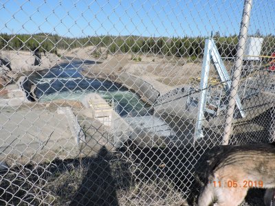 Rio Tinto are now the company owners. The production of aluminium and the company profits are a questionable plus for our society. For example, on the debit side, the longest Chinook Salmon run and the declining White Sturgeon population have been hard hit. In the 1940's and early 50's there was far less concern about damaging the environment and losing valuable farmland. The Nechako flows northeast also draining the Fraser and Stewart Lake systems and eventually flowing into the Fraser River at Prince George.
The following morning we stopped at Ootsa Landing. It was sunny with a light breeze off the lake. This huge body of water is still peaceful and ruggedly beautiful. It is protected by the Coastal Mountains to the west. We marveled at our good fortune to walk this pristine beach. Across the lake is the wilderness landscape of Tweedsmuir Provincial Park. It is the largest park in the province and named for our 15th Governor General Lord Tweedsmuir. Access to the park is by boat or float plane. In the book,"We Pioneered", Arthur Shelford describes how he and his brother Jack reached Hazelton by boat in 1910 and walked to the Ootsa Lake area. It was a distance of about 240 km. without roads or bridges. They swam with the pack horses when necessary. They homesteaded at the west end of Ootsa Lake. Their only complaint was about the mosquitoes and No-see-ums. Their winter supplies comprised of 600lb. flour, 100lb.beans, 200lb. rice, 200lb. sugar, 100lb. bacon, rolled oats for breakfast cereals with dried apples, baking powder, baking soda, salt and a good supply of tea and condensed milk, plus a little canned butter and bacon grease. Those supplies are a little different from what we enjoy today in our RV, the Bird Mobile. 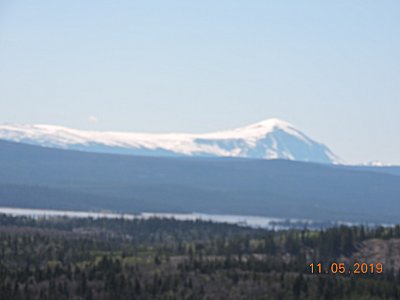
If you would like to know more about the Lakes District in North Central BC, the Interlakes Area or the Nechako Plateau try: Visit Bulkley-Nechako Discovery app or visit www.visitbulkleynechako.ca The Heritage Center at Burns Lake was also very helpful. |