by John Neville
Crossing the Fraser River Bridge to Prince George we were impressed by the aortic flow of muddy water below, draining the BC heartland. We turned westward on Highway 16 to Vanderhoof, "the geographic centre of BC". I wanted to learn more about the absolutely amazing Nechako White Sturgeon!
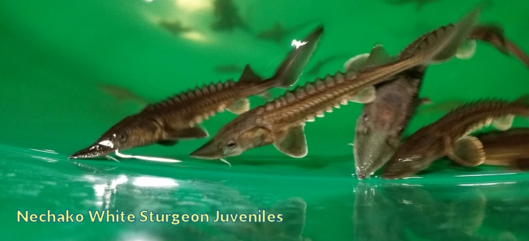 At 2 PM every day there is a guided tour (https://vanderhoofonline.com/nechako-white-sturgeon-conservation-centre-hatchery-tours/ ) at the Nechako White Sturgeon Conservation Centre. These fish have a cartilaginous skeleton and just like sharks evolved about 200 million years ago. We were lucky enough to see 6 mature fish in a large tank with a steady flow of fresh water. The largest was about 2 meters long. Their tilted pectoral fins and upright tail give them the shape of a Boeing 737. In addition they have four small feelers or barbels under the jaw. Like Orca the sturgeon's favourite prey are Sockeye Salmon. A mature female can release about 750.000 eggs per year. The males are mature at about 25 years and the females in their mid forties. We were there when bleachers were installed so that people can watch eggs and milt being stripped from adults and the fertilized eggs placed in another holding tank. The captured mature fish are then released back into the river. Young fish are kept till they are 30 - 40 cm. long in order to have the best chance of survival in the Nechako River. In natural conditions, the eggs hatch in a little more than a week on the river bed. The nutrients from the egg provide an initial food source. Swift flowing water over a gravel bed during the spring flood is ideal. Mortality occurs from: suffocation by silt, disease, large fluctuations in temperature, water pollution, predation from invertebrates, fish and birds. In the river the larvae eat the yolk-sac and move into clean gravel in slower currents to hide from predators. From 10 - 24 days they look like tadpoles. From 24 - 40 days they become free-swimming and reach up to 3 cm. in length. These little tadpoles live amongst the gravel and feed on invertebrates and zooplankton. From 40 days- 15 years they develop into juvenile sturgeon. At that time they may be a meter long and weigh as much as 10 kg. Their food are small salmon, trout and invertebrates. Their preferred habitat are deep pools, back eddies and slow moving areas with a sandy substrate and plant cover. Predators are otters, birds and anglers. From 15-20 years they become sub-adults. 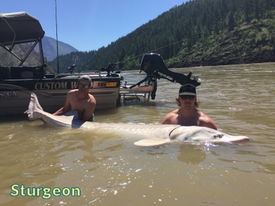 Anna is a 100 year old, who is caught sometimes in spring and produces those 750.000 eggs for the conservation center. The need for the center occurred after the Kenney Dam was built in 1952. River flows and temperatures changes were no longer consistent for the fish. The center sees their role as temporary until the river is stabilized. Later in Prince George we stopped to see the marsh restoration and trail building by the local naturalist club. One of their members, Mike Nash has written a very useful book, "Exploring Prince George, a guide to North Central BC Outdoors". Our journey north from Prince George to the Alaska Hwy is 387 km. Hwy 97 has been renamed along this route: The John Hart, after a former BC Premier. We will cross the continental divide at Summit Lake, then follow the Crooked River north to McLeod Lake and crossing the Parsnip River in the northern Rocky Mountain Trench. Hwy 97 then ascends the moist west side of the Rockies into Pine Pass. The road follows the Pine River down the eastern slope, out onto the prairies and the true Boreal Forest. As we travelled north, the Douglas Firs slowly disappeared giving way to Black Spruce trees. I did hear the iconic voice of White-throated Sparrow but its not till you cross the Rockies that you reach the true boreal ecosystem.  Near the Parsnip River crossing, we turned left onto Highway 39 and followed the Parsnip north to Mackenzie. The community is named for Alexander Mackenzie, who passed this way in June 1793 on his way to the Pacific. He was the first European to complete a crossing of North America. I hope Mackenzie had the opportunity to enjoy the natural music of a Hermit Thrush, as I did at dawn. The Bird Banding Station is open for two months starting in mid July, and is a great place for learning about birds and their migration. Check out mackenzienatureobservatory.ca. A BC Nature member happened to be the greeter at the visitors centre and was very informative. Williston Lake is shaped like a capital T. The cross-bar fills the Rocky Mountain Trench for 250 km. with McKenzie at the southern tip. The stem of the T penetrates the Rockies occupying the Peace River Valley, flowing east to the Bennett Dam. The lake (reservoir) occupies 170 km2 and is one of the few man made structures visible from space! Continue to Part 2 |