by John Neville
Ascending Pine Pass on Hwy 97 in the springtime is perfect to see this part of the Rockies. The snow was melting above and sheets of water were cascading down the cliff face and crashing into the ditch alongside the vehicle. Pine Pass is only 933 m. above sea level. The road passes Azouzetta Lake and follows the Pine River Valley to Chetwynd. At Chetwynd we reached the crossroad with Hwy 29. A right turn takes you to the Tumbler Ridge Geopark. The geological history of the area is fascinating. See Tumbler Ridge article 2017 Spring issue of this magazine.
We turned left and stopped for the night at the Moberly Lake Provincial Park. The lake is long, narrow and quite muddy. A little Black bear was grazing on the lush grass on the way in. He was full occupied and didn't bother to look up. We were pleased to occupy one of the attractive campsites by the water. Our campsite was all-the-more enjoyable because a pair of Merlin were nesting in an adjacent Black Spruce. Our next stop was the museum at Hudson Hope. It is the third oldest European settlement in BC, after Fort St John and Prince George. There were some well displayed fossils from the Peace River Valley. These included 9 dinosaur species and several marine lizards called Ichthyosaur. A small, rare one has been named after the community, Hudsonelpidia. The only other two examples were found in China. 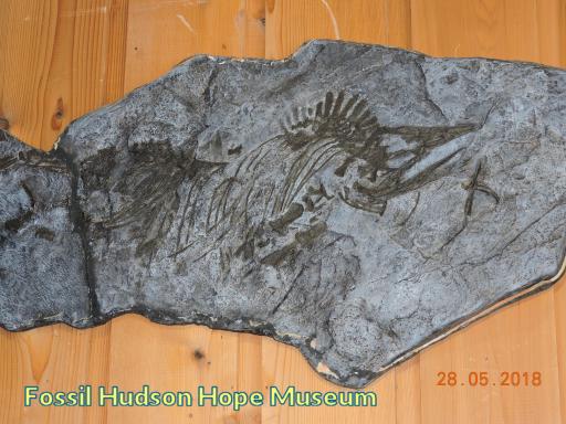 Next, we drove into the W A C Bennett Dam Visitors Centre™ for its 10 o'clock opening. A drivers licence was needed to pass security, then we were quickly fitted out with BC Hydro vests and hard hat. A bus took us down to water level and into the heart of the dam. The dam is 183 m high, a full two km. long and 1 km thick at the base. It is earth filled and designed to withstand an 8.7 earthquake on the Richter scale. We were shown the pen stocks, loud humming turbines and the tail race leading the rushing water out again into Dinosaur Reservoir. The water in the reservoir flows down to the Peace Canyon Dam thus using the water twice. Many fossil bones and dinosaur tracks are now at the bottom of Dinosaur Reservoir. This huge complex provides about 30% of BC's electrical needs. 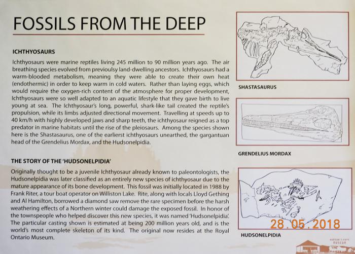 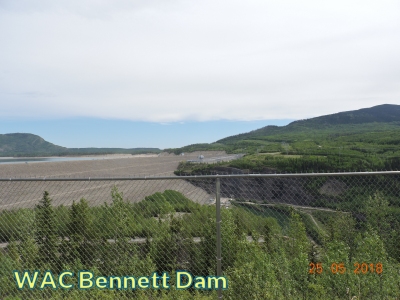 Back in the 1950's the population of BC was growing, mills and mines were being built and the general population was acquiring washing machines, fridges and televisions. BC Hydro and the Bennett government devised plans to meet the province's growing need for electricity. They utilized the Peace River system and in combination with the US, the Columbia River system. The planning was sound from an electrical point of view, but the cost to the First Nations and the natural world were devastating. In 1899 Treaty 8 was signed covering most of the First Nations in this region. It calls on us all to protect the First Nations traditional way of life and to work together on land-use planning. A copy of the Treaty is displayed at the entrance to the visitor's centre. You can see a short film explaining the trauma to First Nations in 1968. When the Williston Lake filled 350,000 acres of forest land was flooded.
 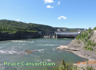 The Peace River system was a highway between nations, with highly organized social structures, laws and means of hunting and fishing. The traditional migration routes of Caribou were obliterated and their numbers have severely declined. Many animals were drowned including more than 200 moose. The new lake created a climate of its own, was dangerous to travel and disrupted many aspects of first nation life. The people were treated poorly. Promises made, such as free electricity, were never kept. BC Hydro is being very open about the benefits and short comings of this huge project. We camped next to Williston Lake for two nights and experienced its turbulent weather. The first night we had a severe wind storm which rocked the vehicle. The next evening the wind blew over the dam creating a sand storm forcing grit through the closed doors and covered all interior surfaces. The next morning, in peaceful conditions, I walked along an adjacent road and recorded several boreal bird species. I particularly enjoyed the melodic song of a Rose-breasted Grosbeak perched at the top of an Aspen tree. Highway 29 continues down the broad Peace River Valley to Charley Lake on Highway 97, better known as the Alaska Highway. This put us back on track going north. We were about 80 km up the road from Mile Zero. Back to Part 1 |